
301 Moved Permanently
W hen Duke Energy’s emerging technologies office brings new ideas to the table, the team looks at the viability of the technology as a business case for the company, which owns coal, hydroelectric, natural gas, nuclear and renewables facilities across the U.S. - including hundreds of megawatts of solar power in North Carolina alone.
If Duke doesn’t think the technology would make a good fit for the company, it moves on to the next idea.
However, when the emerging tech team started looking into drones a couple of years ago, that certainly was not the case.
“They investigate a lot of things, they bring them to the attention of our businesses, but if the businesses don’t see any value in them, we just let it go,” says Randy Wheeless, Duke Energy’s communications manager.
Following what he calls “a lot of homework over the last two years,” Wheeless is confident that unmanned aircraft systems (UAS) can transform inspections of infrastructure - in particular, solar projects.
Just about two years ago, if you wanted to use a drone commercially in the U.S. - i.e., make a profit from it or use it as part of your business, such as for renewable energy infrastructure inspections - you had to apply for an exemption with the Federal Aviation Administration (FAA). This even included using a drone to capture an aerial shot of your project for marketing purposes.
Although the agency certainly picked up the pace in granting the golden tickets throughout 2015 and 2016 - considering only seven companies had inked one by the start of 2015, and the 1,000-exemption mark was reached that summer - the barrier of entry into the commercial drone sector was pretty high: Among other requirements, operators needed to obtain a manned aircraft pilot license.
Those days are over.
As of Aug. 29, a clear set of rules for operating a drone commercially is now set in stone: If you’re planning to fly an under-55-pound drone within your line of sight, not directly over people, not at night, and below 400 feet in altitude or within a 400-foot lateral radius of the structure you’re inspecting, you can now apply for what is called a “remote pilot airman certificate.”
You no longer have to have a pilot’s license; instead, you need a TSA screening and a passing grade on the remote pilot exam at an FAA-approved testing center. For those with existing pilot certificates, it’s an online test.
Floodgates, you can now open.
Easy as 1-2-3
When Duke Energy received a coveted Section 333 exemption from the FAA last July, it was given the green light to go ahead and see how exactly drones could transform its businesses, including for trial inspections of its Marshall Steam Station, a coal-fired plant whose property also houses a solar facility and transmission and distribution power lines.
Wheeless explains that through Duke’s test cases, “solar, in particular, made a lot of sense right off the bat.”

He admits that in a standard inspection process, walking through each row of an array and making sure each panel’s output is where it should be is “a bit of a tedious process.”
John Marciano, partner at law firm Akin Gump Strauss Hauer & Feld LLP, agrees. “In a non-drone circumstance, you would have someone walking the entire site and checking every single panel; that’s just not efficient,” he says.
On the other hand, as he puts it, the process of using a drone to survey a solar array is a bit like that of mowing the lawn: Row by row, the aircraft hovers over the project until it has surveyed the entire area.
After it scans each panel, you can check out the results on the computer, “zero in on the [panels] that are operating at a slightly different temperature than the rest” and, in turn, “have a really good path to identifying a problem,” Marciano explains.
Specifically, notes Liana Ugnat, sales manager at drone and software company senseFly, when you create a georeferenced thermal map from the UAS imagery, you can identify the exact locations not only in which the solar cells are malfunctioning, but also in which dust or dirt has built up, as both issues will appear on the thermal imagery.
“Thanks to this georeferenced map, you can directly attend to problem areas instead of having to inspect each panel one at a time,” says Ugnat.
Benjamin Pinguet, application engineer at senseFly, explains how the process might work from start to finish: Using software, you choose the area you want mapped; the software creates a flight plan; the UAS, equipped with a thermal camera, conducts the flight autonomously and lands when it’s done; and, once uploaded to the computer, the images can be made into a 3D model or georeferenced thermal map.
“With this map, you have all the information taken from thousands of pictures in one single image,” Pinguet says, noting that you’re also able to store photos and make comparisons in order to track defects or make sure a repair has been made since a previous inspection.
According to Wheeless, a manual inspection for a solar facility of just a few megawatts could take up to a day to complete manually; with a drone, the time can be sliced to “just a few hours,” he says.
DroneDeploy, which provides a cloud software platform for commercial UAS operators, recently partnered with drone and camera manufacturer DJI to enable autonomous flight, data capture and landing of DJI drones via iOS or Android device.
Darr Gerscovich, DroneDeploy’s senior vice president of marketing, describes it as a three-step process: one, the drone does its thing; two, the imagery is processed in the cloud; and three, you analyze it and share the maps and 3D models across parties.
For Duke Energy, the data analysis part of the equation - in addition to choosing which drones and software to use - has been a learning process, Wheeless says.
“You get a lot of data out of these drones,” he remarks.
Before Duke goes from testing the technology to implementing it commercially throughout the business, the company plans to do more research and training.
“We’ve done a lot of work, but it has just been a matter of making sure that we understand the technology before we make a real commitment and that the individual business is accepting of that,” Wheeless says.
For FLIR Systems Inc., a longtime provider of thermal imaging technology, the process of capturing this data is “highly variable” and is dependent on the “expertise of the people doing the inspections and the specific things they’re trying to accomplish,” says Andrew Saxton, the company’s director of marketing.
“Many people just need qualitative imaging. That is, they’re not trying to measure temperature but are using the airborne platform to scan large areas quickly and highlight specific areas that need further inspection from the ground.
“Inspectors who are also certified thermographers may use the aerial inspection package to capture radiometric temperature measurements that can be accurately analyzed in FLIR Tools software. There are lots of variables involved with this, however - like eliminating reflections and correctly measuring the target’s emissivity - so most opt to gather qualitative data instead of quantitative data,” he explains.
Cutting costs, upping safety
With the FAA’s new rules in place, Duke Energy plans to make the transition to drones by bringing the operations in-house.
Though Wheeless says the company has been happy to work with third-party drone inspectors for testing, now that the requirement to have a pilot’s license has been removed, Duke will be able to segue over to doing the job itself.
“Not having to have a pilot gives us more options,” he explains.
“We’re planning to train [our own] technicians on this technology so they can do it themselves,” he adds.
Marciano brings up the cost factor, too: The pilot license requirement, he says, was “completely unrelated to flying a drone” and could have cost thousands of dollars to obtain.
“That prices a lot of people out,” he says.
Now, for inspecting or photographing small-scale solar projects in particular, he says, you can look to hire a drone company or even become a commercial drone pilot yourself for a lower cost than before.
“Getting the cost in line with the money you expect to make from the project is a really important piece,” he explains.
Mike Winn, CEO and co-founder of DroneDeploy, brings up an added benefit for rooftop solar, especially: safety. Instead of hiring someone to climb up onto a roof and check out the scene, you can perform an unmanned inspection at a lower cost and without bringing a person up a tall structure.
Thus, DroneDeploy’s goal, he says, is “putting a drone on every [solar] job site.”
“Every time you put somebody on the roof, you double the price,” Winn says. “Now, you can just use a drone.”
Ryan Tong, DJI’s director of marketing, notes in a press release that even though rooftop inspections have not “changed significantly over the past decade,” bringing forward “safe and accurate drone-based 3D models to replace survey wheels and measuring tapes is a step forward for the [solar] industry.”
Moreover, Marciano adds, now that the technology has developed extensively over the past couple of years, you’re able to use fewer people on-site to get the inspection or photography done: After all, as senseFly and DroneDeploy explained, the drone can even conduct the flight on its own.
Enabling another way to decrease the number of people needed for the job, the FAA has also removed its previous requirement for the drone pilot to bring along a visual observer, which the agency defines as “a person who assists the operator to see and avoid other air traffic or objects aloft or on the ground.”
For FLIR, using a camera-equipped UAS for solar inspections saves time and energy not only in the inspection process itself, but also in the preparation for the inspection.
Late last year, FLIR and DJI announced that they would be mating their respective technologies to expand thermal imaging to more commercial drone operations, including for the solar industry.
In their first line of business, they created the Zenmuse XT camera, which, according to Saxton, puts a “sophisticated, turnkey flying thermal imaging solution in the hands of inspectors around the world.”
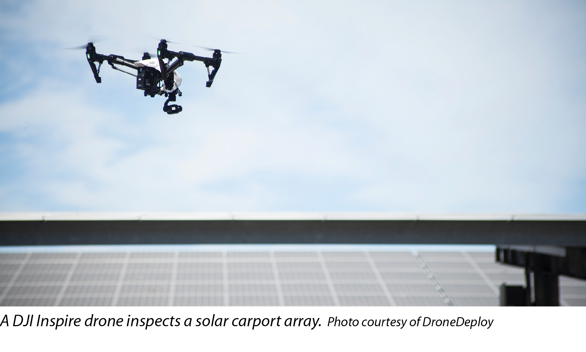
Compatible with DJI’s Matrice 100 and Inspire 1 drones, the thermal camera is also being integrated with DroneDeploy’s cloud-based software.
“Until this solution came out,” Saxton says, “it would take someone the better part of a year to research, engineer and refine a flying system that wouldn’t give him as good of an end result. Now, a DJI Inspire or M100 with a Zenmuse XT installed is ready to fly and gather thermal data right out of the box.”
He says that although FLIR’s technology has been prevalent for solar panel inspections for years now - e.g., through handheld sensors - bringing the cameras to unmanned technology brings something new to the table.
“Being able to do this from an airborne drone just adds another dimension to a proven application,” Saxton says.
And for small solar sites in particular, adds Marciano, you can now rely on an aerial view from 100 feet above rather than thousands of feet above (e.g., through Google Maps) for scouting a site for development.
Do the rules rule?
So, the federal rules governing the commercial operation of drones in the U.S. have been established. What now?
“Fundamentally,” remarks DroneDeploy’s Gerscovich, “the rules are a big enabler.”
In fact, DroneDeploy remains so optimistic about the future of UAS in solar that it set up shop, along with DJI, at this July’s Intersolar North America in San Francisco, where the companies’ drone demos received a warm welcome from show-goers, says Gerscovich.
However, it’s certainly not a free-for-all: As mentioned earlier, operators must not fly beyond their visual line of sight (BVLOS), among other requirements.
Wheeless says the BVLOS rule may pose a problem for Duke Energy’s inspections for transmission and power lines, seeing as they can stretch for miles, but he believes the company’s solar facilities would be in the clear. At worst, a larger project’s inspection would simply take a bit longer to complete, but the operator would typically be able to keep the drone within his sight.
FLIR’s Saxton notes that although the BVLOS rule may keep other “industry innovators from unleashing the complete power of [drone] technology,” drones simply have “so many benefits that users are putting up with the regulatory limitations as an inconvenience rather than a roadblock.”
In other renewable energy markets, such as wind power, for instance, a project may be too massive for the operator to stay within the line of sight of the drone, but, again, under the new rules, the issue of staying under 400 feet in altitude has been removed: Before, a UAS was not allowed to exceed 400 feet in altitude; now, if you stay within 400 feet laterally of the structure you’re inspecting - e.g., a 500-foot turbine - you’re good to go.
When the FAA unveiled the new rules at a press conference a few months ago, Administrator Michael Huerta emphasized the agency’s willingness to be flexible in order to further advance the commercial drone industry: If you want to fly BVLOS, fly at night or use more than one drone at once, for instance, the door is open to apply for additional waivers.
As long as pilots are able to “demonstrate how to ensure safety and visibility,” Huerta explained during the June conference, they are welcome to seek additional authorization from the agency, which is facilitating the waiver process through a Web-based system.
“Our focus is to make this as streamlined as possible,” he said. “We do not envision this being a very burdensome process.”
Matt Delano, senseFly’s field operations manager, notes the importance of the FAA’s new waiver process.
“This is substantial because it shows that they have considered exceptions and positively accepted feedback given from the business community during the conception of the new rules,” he says, referring to the thousands of public comments the FAA took into account when it finalized the rules between February 2015 and June 2016.
Don’t rule out humans
Duke Energy’s Wheeless says the company aims to eventually deploy unmanned aircraft “100 percent of the time” for its solar inspections.
“We’d like to have this at all of our solar facilities,” he says.
In fact, Marciano says he believes every solar developer could eventually have a drone on-site - “in a lot of different capacities”: e.g., marketing, site development and inspections.
Still, not everything can become unmanned.
Saxton explains, “Beyond periodic inspections to find possible trouble spots, FLIR cameras let installers provide a visual record that everything was working properly when a panel is first installed.”
However, he points out, “They give maintenance workers the ability to document repair work.”
Drones, explains Marciano, are a “good cursory tool to identify where there could be a problem,” but you still need a person there to go and fix that problem. The drone can’t do it all.
For now, at least.
After all, it is 2016: the age of autonomous cars, autonomous drones, autonomous this and that. Who knows who - or what - could be making the repairs in the years to come.
“We’re excited to see where it goes from here,” says Saxton.
Drones
When Solar Goes Unmanned
By Betsy Lillian
Now that federal rules are finally in place for commercial drone operations, the U.S. solar industry is ready to bring the technology on board.


si body si body i si body bi si body b
si depbio
- si bullets
si sh
si subhead
pullquote
si first graph
si sh no rule
si last graph